|
| Uluru from Imalung Lookout - midday... |
 |
| ...And at sunset... |
 |
| ...And at sunrise |
On September 27th, we found ourselves back at
Canberra Airport for a short flight to Sydney where we caught our three-hour
flight to Ayers Rock Airport. From there
it was a short shuttle ride to the Ayers Rock Resort, a sprawling complex that
is THE township of Yulara, the only place to stay in this part of the Red
Centre of the Northern Territory. The
landscape here is most closely associated with Australia’s Outback – red sand
desert stretching for miles and miles in every direction under beautiful bright
blue skies. When here, you feel that you
are truly in the middle of nowhere!
 |
| Ghost gum trees at Ayers Rock Resort |
Ayers Rock Resort is an oasis in the middle of this vast red
desert, 12 miles from Uluru (Ayers Rock) and 33 miles from Kata Tjuta (the
Olgas). Huge sails provide shade and
native trees thrive throughout. The
desert here receives an average of seven inches of rainfall per year. However, this year almost eleven inches has
already fallen and the desert floor is in full bloom. A ranger reported that plants that have not been
seen for ten years are sprouting!
 |
| Wild flowers in bloom |
The resort is able to generate its own electricity through
several solar generating fields. It is
also able to find enough water to sustain its needs. But everything else must be trucked in over
long distances over a very inhospitable terrain. Twice a week, three fully-loaded ‘road
trains’ (multiple trailers hauled by one semi-tractor with a combined total
length of 180 feet!) arrive with food from Adelaide, 990 miles away. Other trucks hauling other necessities arrive
daily from Alice Springs, 300 miles away.
The road train returns to Adelaide with the resort’s accumulated
recyclables.
After checking into our room in the Outback Pioneer Hotel,
one of four hotels in the resort, we hustled over to Imalung Lookout for a good
look at Uluru. This rust-colored mammoth
sandstone boulder with a circumference of six miles rises 1,141 feet over the
flat desert and is said to continue below the ground for over three miles. It shows a dazzling variety of colors
depending on the time of day it is viewed.
Prior to our arrival, Yulara had some rainfall, so the desert floor was
just coming into bloom with wildflowers – red and yellow Grevillea, pale pink
Sturt’s Desert Rose, yellow Mulga, and the bright red Quandong.
 |
| At Uluru-Katya Tjuta National Park |
An excursion to Uluru-Kata Tjuta National Park brought us up
close to Uluru. From a distance Uluru
looks smooth but close up it looks more like a weather-beaten rusty rock with
dappled areas of flaky red skin and pockmarked with holes and coves and caves
that are of sacred significance to the Anangu, the native people who are the
caretakers of the park. The Anangu believe that the features of Uluru are
related to the journeys and actions of ancestral beings across the landscape during
the creation period – Kuniya (python woman), Liru (poisonous snake man), Mala
(rufous hare-wallaby) and Lungkata (blue-tongued lizard man).
 |
| The red skin of Uluru |
We joined a ranger for the Mala walk to Kantju Gorge. The morning was very, very windy but the
ranger managed to lead us into several caves along the base of Uluru and
explain their cultural significance. He
also asked for everyone to understand why the Anangu request that visitors not
climb Uluru since the climb’s pathway is the same route taken by ancestral Mala
men on their arrival here. While this is
a request, the climb is not expressly prohibited. It was not an issue on the day of our visit
since the winds were howling at the base and at the top causing the park to
close the path. At the park’s cultural
center, visitors are encouraged to sign the ‘I-didn’t-climb-Uluru’ guestbook.
 |
| Kata Tjuta |
 |
| Sunrise at Kata Tjuta |
Frank rose one morning in the pre-dawn hours to join a
busload of hearty souls to see the sunrise over Kata Tjuta. Kata Tjuta (many heads) is comprised of
thirty-six rock domes, the tallest of which is higher than Uluru. I was content to wander back to Imalung
Lookout to observe sunrise over Uluru.
It was a cold, cold morning in the desert - 39⁰.
One of the highlights of our stay in Ayers Rock Resort was A
Night at the Field of Light. One hour
before sunset we boarded a bus to the Uluru sunset viewing station. The camels were heading back to the resort’s
farm after a day of ferrying tourists through the desert as we were enjoying
champagne along with crocodile frittata and kangaroo canapes. Our guides
escorted us to one of ten dinner tables where they kept the wine flowing. As the skies darkened, the table lanterns
were extinguished and the resident star talker pointed out the Southern Cross
and other Southern Hemisphere constellations.
A leisurely stroll through the Field of Light, a solar powered art
installation, capped off the evening.
 |
| Sunset over Katya Tjuta from the Uluru sunset viewing station |
The Field of Light was conceived by internationally-known
artist Bruce Munro and required 3,900 hours to assemble on site. Stretching over eleven acres of the desert
floor, fifty thousand frosted spheres gently sway on stems planted among the
clumps of prickly spinifex. The
twinkling lights of the Field of Lights combined with the dazzling star lit sky
– what a magical display!
Our stay at Ayres Rock Resort was over much too quickly. On September 30th we boarded our
Qantas flight to Alice Springs, the unofficial capital of the Red Centre. It was a quick 45 minute flight over 300
miles of desert and the rippling mountains of the MacDonnell Ranges. Alice Springs was settled in the early 1870’s
as a telegraph repeater station that would link Adelaide with Darwin and the
rest of the world. “The Alice” is the
only big town (25,000 people) in Central Australia and the second largest city
in the Northern Territory. It is the
heart of the Aboriginal Arrernte people’s country. We saw the largest numbers of indigenous
people here on the streets of Alice.
 |
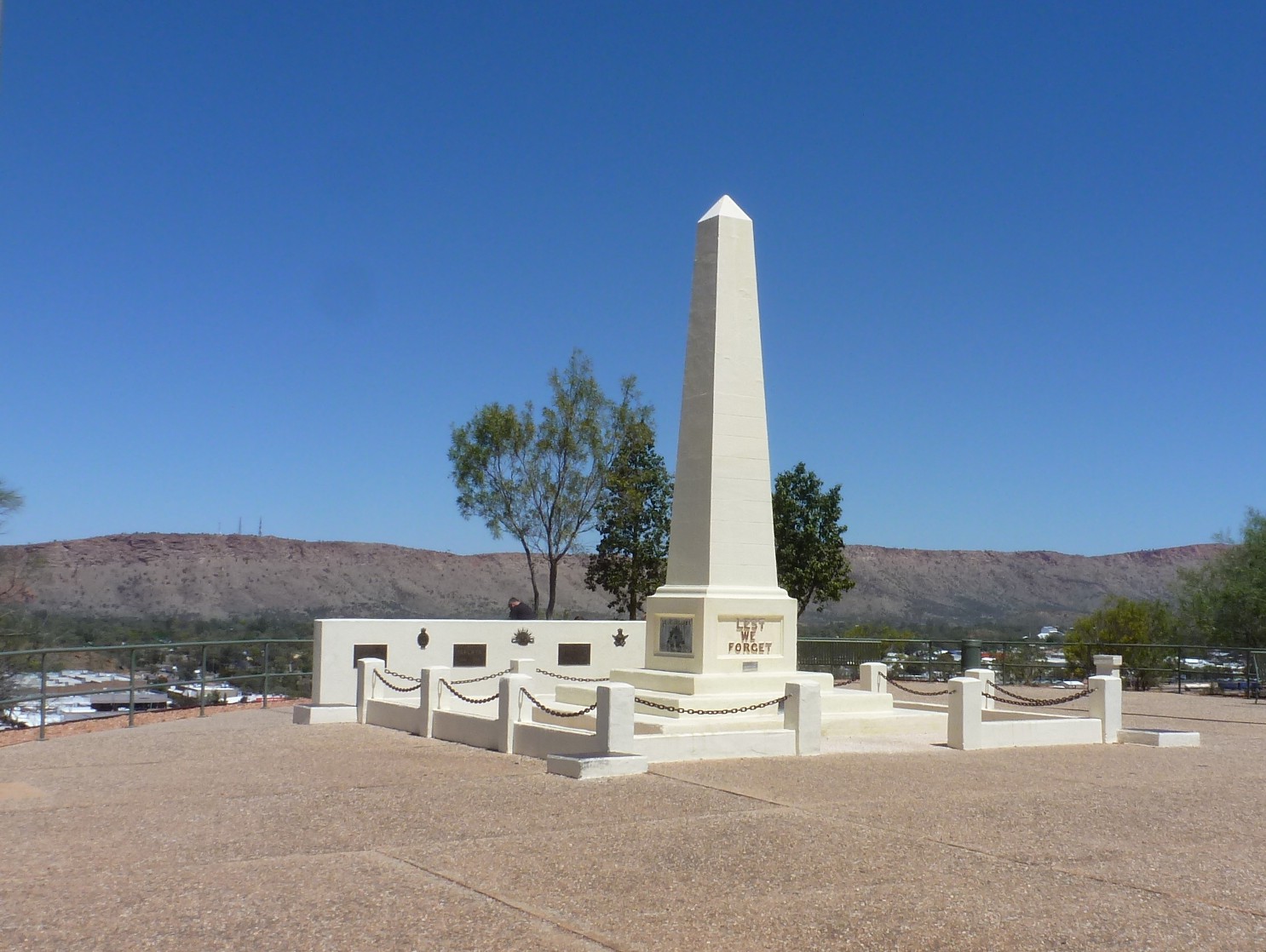
| Alice Springs from atop Anzac Hill |
The six-hour layover between landing in Alice Springs and
our next flight to Darwin gave us the opportunity to head into town. Our taxi driver deposited us at the top of
Anzac Hill Lookout for a panoramic view of Alice and the surrounding area. Originally dedicated to those who served in
World War I, the Anzac Hill monument now serves as a memorial to all servicemen
and women who served in all the wars and conflicts both before and after WWI.
 |
| Memorial atop Anzac Hill in Alice Springs |
While atop Anzac Hill, I noticed a young woman walking a dog
sporting a University of Michigan collar.
We engaged the woman in conversation and found that she was a recent U
of M grad who was now working in Alice Springs.
Another woman at the top was from Maine and she asked us for directions
to the shopping district. We must look
knowledgeable! Anyway, we Americans were
the only visitors on the top of Anzac Hill at the time.
 |
| The mighty Todd River |
There was not much going on in Alice. Other times of the year Alice hosts such
events as the Camel Cup Race and the Henley-on-Todd Regatta. Now that would be a bizarre event to attend
since the Todd River only flows three days a year - the homemade boats race
down the dry Todd River bed! We made our
way down the Lions Walk to the Red Ochre Grill for a bite to eat before heading
over to the Royal Flying Doctor Service, a small museum telling the story of
this airborne medical service that treats the people living in the vast and
remote Outback. Then it was back to the
airport…
When we stepped out of the arrivals building at the Darwin
airport after our two-hour flight, we were overwhelmed by the heat and humidity
at 8PM. Whoa!! This was tropical! We were glad to hop in a cab and check into
the air-conditioned comfort of the Adina Apartment Hotel at the Darwin
waterfront.
Darwin is the largest city in the Northern Territory. This is the Top End of Australia, a sort of
last frontier – isolated with predatory crocodiles, deadly marine stingers and
a sometimes inhospitable tropical climate with monsoons, cyclones and just two
seasons, the Wet and the Dry. We are
visiting in the Dry when it is hot and humid but the upcoming Wet is even
hotter (104 ⁰ is typical) and more humid with heavy downpours that flood the
surrounding area and cut off access to many of the tourist attractions.
Darwin is a city that has suffered a great deal of
devastation – some wrought by man, some by Mother Nature. On February 19th, 1942, the same
Japanese attack force that bombed Pearl Harbor ten weeks earlier bombed
Darwin. In anticipation of an attack,
the civilian population had been evacuated to safer places just weeks before
the 242 aircraft descended on Darwin. It
was the first of 64 Japanese air raids on the city. To the Japanese, Darwin was an important strategic
target – not only was it a supply base and fueling station for the Allies naval
vessels and planes, it was close enough to Timor and Java for the Allies to
militarily contest Japan’s invasion of those islands. Across the street from our hotel is the
entrance to the now empty World War II oil storage tunnels constructed after
the above ground tanks had been destroyed in the first air raid. Surprisingly, these tunnels which are now a
tourist attraction were kept secret from the Australians until 1992 when they
were revealed as part of the 50 year commemoration of the war. Why so secretive? The
Australians were concerned that the Cold War would erupt into a real war.
 |
| Inside the WWII Oil Storage Tunnels |
On Christmas Eve 1974, Cyclone Tracy wiped out the city of
Darwin and the majority of its buildings were constructed afterwards. As a result the city is very modern looking
with high rise residential buildings and hotels, and a recreation area at the
waterfront that includes a wave pool and a large lagoon. A stinger-net in the lagoon supposedly offers
swimmers some protection from the stinging jellyfish of the Arafura Sea. However, two people had been stung over the
past few days and authorities had closed the lagoon until divers completed drag
netting and stinger spottings. A
spokeswoman was quoted as saying, “Some marine stings here will always be
possible.” I know two people who will
not be visiting the lagoon when it reopens on Sunday…
The weekend news here in Australia seems to center on two
things – the U.S. Presidential election and the AFL final game between the
Western Bulldogs and the Sydney Swans.
The Bulldogs won that game of Australian football – we attempted to
watch the game on a big screen TV in a local bar but we did not get much out of
it. We did not know the rules and were bewildered
by the commentators’ lingo – ‘he gets half a sniff,’ ‘he toned down his
infamous niggle,’ ‘he charges through the middle of the ruck,’ disposals,
stoppages, involvements, and contested possessions??? More bewildering to the Australians is our
election. A common comment – “Is this
the best slate of candidates you can come up with?” And this surprising observation – “You know,
the whole world will have to suffer the consequences of this election.”
A chuckle from the Sunday edition of the Northern Territory
Territorian newspaper. The headline on
the page with wedding announcements and birth announcements read HITCHED AND
HATCHED.
Early on the morning of October 3rd we joined a
day trip tour to Litchfield Park. With
us on the tour was an assortment of Aussies, Brits, Italians, Germans,
Japanese, and one University of Virginia grad student. Along the way we drove through mango groves,
spotted a few wallabies, learned that this was open hunting season for magpie
geese (an annoyance here just like Canada geese are at home), passed many road
trains (even a five trailer) and stopped for coffee in the town of Humpty Doo
before arriving at Pat’s Place for a cruise and crocodile sighting on the
Adelaide River. It was quite a thrilling
experience to see the crocodiles up close.
Pat, looking as if he just stepped off the set of Duck Dynasty, told us
that the males are a bit sluggish because all their energy is geared towards
mating season. We all agreed that they
were looking mighty active! An interest
tidbit he conveyed – for every croc you see there are sixty more lurking in the
water and the surrounding muddy river bank.

 |
| This male croc was enticed to come close to the tour boat by a hunk of chicken dangling off Pat's fishing pole. |
Our first stop in Litchfield Park was at the termite mounds.
Cathedral termite mounds are built by termites that feed on plant litter. It takes about ten years to build up three
feet so this mound is about 50 years old.
 |
| Cathedral termite mound |
Magnetic termite mounds are built by termites that feed on
grass. They are called magnetic because
they are all built in alignment with the magnetic north and south poles –
positioning the most exposed ends away from the sun. They resemble grave stones.
 |
| A field of Magnetic termite mounds |
Some of the roads through Litchfield Park are only
accessible via four-wheel drive vehicles.
Our tour guide described these roads as “absolute bone shakers” and we
would not be traveling on any of them.
An interesting bird is the bower. He constructs his unique bachelor pad,
decorates its entrance with shiny things like bottle caps and seashells, all in
an elaborate attempt to woo females. The
females lay their eggs in their own nests in the trees.
 |
| Built by a bower |
Litchfield Park is home to several swimming holes that are
popular with Darwinians. The first one
we stopped at was located at the base of Wangi Falls. Here is the sign that is posted at the
lookout. Excuse me for not wanting to
jump right in!
 |
| Wangi Falls swimming hole |
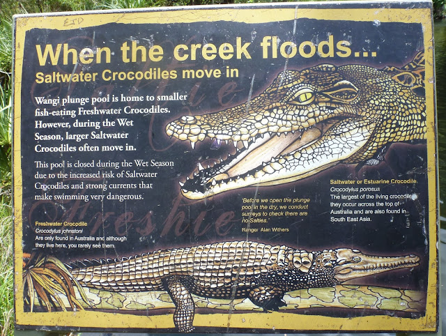 |
Sign at Wangi Falls
|
 |
| Florence Falls in Litchfield Park |